Tag Archives | Selene

Guam to Chile – Blog Post 6

September 14, 15 2024 At Sea between Pohnpei and Bakawari, Papua New Guinea

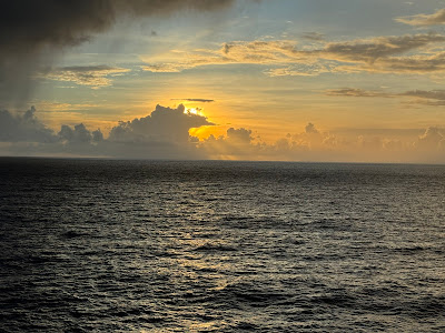
Departing Pohnpei about 1930, Seabourn Pursuit continued south overnight.  The wind and swell were on the beam, with the seas about 10 feet at 9 second period, so the ship had moderate roll motions.  This wave height is typical for the Pacific Ocean, which has an average wave height of 3 meters.

The sunrise was spectacular once again and we had no rain all day.  At 1400 we held the Equator crossing ceremony and my sister, Julie, being a Polliwog, was inducted during the ceremony into being a Shellback, so we now had permission from King Neptune to cross the equator with no Polliwogs on board.

Lectures today included one on Seabirds and another on mangrove swamps.

September 15, 2024 – At Sea

September 16, 2024

The Seabourn Pursuit took up position off Bakawari Island, Papua New Guinea at 0600.  

Bakawari Island lies next to Bougainville Island
Papau New Guinea

The ship was cleared by the local authorities about 0700 and Patrick headed off for a Kayak excursion.  At 0830, other guests were shuttled ashore in color groups and were treated to a folkloric performance by three local groups on Bakawari Island.  The kayak tour finished just in time to be delivered to the beach for the performance.


Dancing at Bakawari Island

Some of the bamboo flutes used by the performers
Native canoes fishing

Coral formation while kayaking

Native Canoe


By 1200, all guests were back on board and Seabourn Pursuit headed for Honiara, Guadalcanal, Solomon Islands, our next destination.  Our route takes the ship down the “Slot”, through Bougainville Straits and past Savo Island before docking at Honiara.

The area we are transiting is larger than we expected.  The distance from Bakawari Island to Honiara, Guadalcanal is 335 NM.  To make that distance overnight means Seabourn Pursuit has to average more than 15 knots.  Fortunately the seas and wind are favorable.

One of the reasons for making this cruise is the opportunity to visit locations in which my father served while in the USN in WWII. 

This morning, with calm seas and sunny skies, we are approaching Savo Island and will pass by the final resting place of the USS Astoria, which sank following a fierce night battle just off Savo Island, only two days after the USMC landed at Red Beach on Guadalcanal.  The night of August 9, 1942, a night attack by the Japanese navy caught the allies off guard.  Four heavy cruisers were sunk, three US and one Australian.  Three cruisers were sunk in just a few minutes between 0230 and 0300.  The USS Astoria did not sink immediately, but was badly damaged.  The crew initially abandoned ship, but later 350 crew returned to try and save the ship.  My father was one of those who returned to the ship.  He told us about jumping off the bow initially, and returning to collect the bodies of those killed and preparing them for burial by sewing the corpses into hammocks while eating stewed tomatoes since the galleys were unusable and on fire.  Initially we were skeptical of some aspects of that story, but when we saw the same story in other eyewitness accounts, we were convinced he had survived a horrific experience.

However, the crews’ efforts were in vain, as underwater explosions in the bow area fatally damaged USS Astoria (my father was aft at that time).  The ship was abandoned once again and at 1215 that day, August 9, 1942 the USS Astoria listed 30 degrees, then capsized and sank stern first in 2800 feet of water about 2 miles from Savo Island.  More than 247 sailors perished and another 250 were wounded.  It was the worst defeat at sea for the US Navy, excluding Pearl Harbor.  The USS Astoria was rediscovered by Paul Allen in 2015, in 2800 feet of water, with the bow missing.

The bridge display as we were at closest point to Astoria

Last known phot of Astoria, one day before sinking

Photo of Astoria remains by Paul Allen

Savo Island


We wer fortunate to be on the bridge of Seabourn Pursuit when we passed just 2.85 nm from the location of the USS Astoria.  We observed several minutes of silence in memory of the hundreds of navy personnel who died in that action on both the Astoria and the other three ships.

My father was then reassigned to the destroyer USS Blue.  That ship was torpedoed on August 22, 1942 and scuttled on August 23, 1942, after unsuccessful attempts to save her.  My father also survived that sinking.

USS Blue – DD-387


The area between Savo Island and Guadalcanal has been named Iron Bottom Sound, since more than 50 allied and Japanese ships were sunk in the 7 month Guadalcanal campaign.  Iron Bottom Sound is considered a sacred place due to all the people who perished and whose remains went to the bottom.  Guadalcanal and the Solomon Islands campaigns marked the beginning of the successful, but bloody island hopping strategy which the Allies used to eventually defeat Japan.

The Battle of Savo Island was also a turning point for the US and it’s allies in that the Japanese failed to destroy the troop transports and supply ships lying off of Red Beach, just a few miles from the Savo Island battle, instead withdrawing after destroying the four heavy cruisers.  The pattern of tactical victory but strategic mistake would persist throughout the war.

Seabourn Pursuit docked at the container port in Honiara, Guadalcanal at 1100, and by 1140 we were on a bus tour of the Eastern Battlefields of the Guadalcanal campaign.  

Honiara is the capital of the Solomon Islands, a sprawling independent nation with more than 95 major islands and a total population of more than 700,000.  Honiara has a population of about 65,000.  This island nation is being impacted by climate change, with sea levels rising 8 mm per year, more than the average worldwide. The evidence of WWII is still present, with significant amounts of unexploded munitions still being discovered 82 years later.

The first tour stop was at Red Beach, where the USMC landed on August 7, 1942, with little opposition.  That was soon to change as the USMC took control of Henderson field (our second stop) and set up defensive perimeters, including one at “Bloody Ridge”, our third stop of the tour.  We finished the tour with visits to the Japanese War Memorial and the the US War Memorial.  The Guadalcanal took seven months to achieve victory, with more than 7,000 Allied deaths and more than 19,000 Japanese deaths.


Monument at Red Beach

Red Beach

Memorial Park at Henderson Field

View from Bloody Ridge

Monument at Bloody Ridge

Japanese War Memorial

View of Savo Island from US Memorial

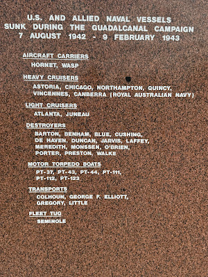
Battle of Savo Island at Memorial


List of US Ships sunk at Guadalcanal


At 1800, Seabourn Pursuit cast off the lines and continued the journey in Melanesia.  Our next port of call is Luganville, Espiritu Santo.

Guam to Chile – Blog Post 5

Blog Post 5 – Pohnpei and Nan Madol

September 13, 2024

Before it was fully light, Seabourn Pursuit took up position outside the barrier reef near the harbor entrance for Pohnpei and the town of Kolonia.  Pohnpei is about 21 KM in diameter, surrounded by a fringing barrier reef.  Pohnpei is also the capital of the Federated States of Micronesia and the island has a population of about 30,000.  There were a number of freighters anchored inside the barrier reef, but the lagoon has many shallow spots and is not really suitable for a ship the size of Seabourn Pursuit.

The trip into the municipal wharf was about 15 minutes-3 miles in the zodiacs.

Patrick had arranged an independent tour to meet Yvonne and David Hawkins.  David is one of the sons of Tom and Joyce Hawkins, long time friends in Anacortes.  I was given a great tour of the local area before returning to the wharf for the trip to Nan Madol.

Pohnpei

Japanese Tanks from the war

The preamble to the FSM Constitution

Capital Entrance to FSM


Nan Madol is a mysterious set of stone structures located at the southwest corner of Pohnpei, 93 artificial islets in the lagoon are linked by stone causeways.  Archeologists believe the structures were constructed in the 1200’s by the Sandeleur dynasty and were occupied up to about 1628. 

The name Nan Madol means “within the intervals” and is a reference to the canals that crisscross the ruins. The original name was Soun Nan-leng, “Reef of Heaven,” according to Gene Ashby in his book Pohnpei, An Island Argosy.

The site measures about 1.5 by 0.5 KM.  Not much is really known about the dynasty or the civilization that occupied Nan Madol.  Nan Madol is sometimes referred to as “the Venice of the Pacific” or even as “Atlantis”. 

In the four hundred years since Nan Madol was abandoned, the jungle is slowly taking over and hence it is listed as a “Threatened World Heritage Site.

Nan Madol is at the opposite end of Pohnpei from the capital, Kolonia, a drive of 26 miles or 1 ½ hours on narrow, rutted, winding roads.  Our drive was in intense rain showers.

Arriving at the trailhead in heavy rain, we started down the trail, ducking under a tree that had fallen earlier in the day.  The trail is made of both chunks of coral and rocks, not level at all.  There were a series of crude bridges across flooded areas in the mangrove swamps.  The final approach to the ruins included wading through knee deep water on a sandy bottom.


Window construction

Mangrove Swamps surround the ruins

Unique and stable construction

Looking across the final channel to the main ruins

Blocks scattered everywhere


One of the many bridges on the trail


The basalt stones are stacked like logs in layers alternating directions, creating a very stable structure without any mortar.  In this climate, no mortar was needed.  The shape of the basalt logs is not round, but mostly 4, 5, or 6 sided.  Only the main temple has been excavated, but represents just a fraction of the entire complex.

Returning back to the trailhead, two more trees had fallen across the trail, so we had to scramble through the trunks and branches blocking our path.  Patrick’s van took up the last position as security for the bus ahead, which had engine problems.  Sure enough, some 25 KM from the wharf the bus finally stalled again, so we were sent ahead to get a replacement bus.  The local fire medics that had accompanied us on the trail were there also and stayed with the bus. Pohnpei is very rugged, with hills to 2500 feet, so the portable radios were useless until within a mile or so of the wharf.   The height of the hills also attracts intense rain, with Pohnpei getting some 7600 mm of rain per year, one of the wettest places on Earth.

A replacement bus was ordered when we got into cell phone range (Pohnpei has a proprietary cell phone system and USA phones do not work), so everyone arrived safely back in the dark to the wharf only an hour or so late.  The crew had beverages and appetizers waiting at the gangway for all of us who were delayed.

Patrick had just time for a quick shower before meeting Miriam and Julie for dinner.


Guam to Chile – Blog Post 4

September 12, 2024 – Oroluk Lagoon

Overnight the ship travelled to Oroluk Lagoon.  There were still some residual effects of the low pressure zone the ship passed through on the voyage from Guam.  The ship motions were not as extreme, but still there were shudders as particularly large swells brought the bulbous bow out of the water.  The ship’s clocks will also be set forward one hour tonight as we continue eastward towards our destination, so we lose an hour of sleep. 


Oroluk Lagoon


Oroluk Lagoon is a marine sanctuary and part of Pohnpei State in the Federated States of Micronesia.  The lagoon is a nesting site for Green Turtles and a breeding colony for Black Noddies and other seabirds.  There is only one island left on the atoll, which measures 12 by 20 miles.  The rest have been washed away by tropical cyclones over the years.  There are bananas and Taro plantations on the island, with just a few semi-permanent residents from the Kapinga district of Pohnpei, who are supplied twice a year by ship.  The atoll was “discovered” by Spanish explorers in 1565, but was probably known to the Micronesian people in the area.

Tomorrow the captain will position the ship off the northwest corner of the fringing barrier reef.  The ship will not enter the lagoon itself, nor will anyone go ashore.  Our activities will consist of submersible dives alongside a 800 foot deep wall and snorkeling in a different area, also alongside a wall where the fringing reef begins.  This will be a more strenuous snorkel experience, only for strong swimmers, due to both water depth and tidal currents in and out of the lagoon through a few passes.  Patrick, Miriam and Julie decided to let others partake of this experience.

The ship plans to arrive at 0800 and depart at 1630.  Patrick is currently scheduled for Dive #1 at 0900.  This dive will be a new dive for Seabourn Pursuit, going down the wall to a depth of about 200 meters, or 660 feet.  It should be dark at that depth, so the submersible will be using lights to illuminate the wall and allow passengers to see the variety and different life forms as the submersible moves down the wall and loses the surface light.

For those guests not going on the submersibles or snorkeling there will a variety of lectures and activities, very similar to a day at sea.

OK, what really happened.

The weather cooperated as we approached Oroluk Island at the NE corner of the atoll, the only island remaining on the atoll.  Seabourn Pursuit arrived about 0800 and positioned in a small lee about 1500 feet from the fringing reef and held position with dynamic positioning.  

Oroluk Island at the NE corner of the lagoon


The submersibles and zodiacs were launched and promptly at 0900 operations commenced. Patrick was fortunate to be on the first dive, along with the ship videographer.  The plan was to reach 200 meters in depth and then approach the wall of the fringing reef.  At 50 meters from the wall and 200 meters depth the visibility was so good that we could see the wall clearly without lights.  There was not much life here, but at 150 meters depth we saw oceanic sharks.  Slowly ascending to the surface the life increased until at 50 meters there was an abundance of sea life and coral.

50 meters from the wall at 200 meters depth


Just before lunch Patrick headed out for a short snorkeling session on the reef wall, despite originally planning to avoid.  There were a lot of different types of fish, including a small reef shark, but the coral near the surface was largely dead even though at deeper depths we saw some massive coral formations.

Seabourn Pursuit continued to hold position throughout the afternoon while everyone who wanted to snorkel had a chance and at 1530 we headed around the east side of the atoll and set a course west for Pohnpei, some 200 NM away, our next stop and the location of Nan Madol, a World Heritage Site threatened by climate change.

The rain squalls held off so we experienced the Seabourn Signature “Caviar in the Pool” event at 1700, followed by a expedition recap at 1800.


Guam to Chile – Blog Post 3

September 8, 2024 – Embarkation Day

After a leisurely buffet breakfast we finalized the packing of our bags and waited for the taxi to the port.  The gates to the port would not be open until 12:30, so we did not depart the hotel until 12:15, arriving at 12:45.  Our passports were checked and we took small shuttle carts to a tent where we had to open our bags for inspection by both CBP and USCG before the ship personnel took them aboard. From the tent we either took a shuttle or walked to the gangway, where there was a wheelchair for Miriam. Once up the gangway we headed to the Discovery Center to be photographed and then to our suites.

After freshening up it was time for lunch in the Colonnade Restaurant. After that, the bags were delivered to our suites, and we unpacked while watching the safety video. At 1700 there was a mandatory muster in the Discovery Center and more safety briefings, along with introducing the 25 person expedition team. The briefing concluded with an overview of the next several days at sea and our first stop in Chuuk Lagoon.

By the time the briefings were concluded we had time for cocktails and then to dinner the the main restaurant. The service and food were excellent.

The ship departed Apra Harbor, Guam at midnight, but most of us were asleep by that time.

September 9, 2024

Patrick and Julie met on Deck 9 for a walk at 0600, with a nice sunrise, rainbows and light rain showers. The morning had a mandatory Zodiac and snorkeling meeting, fitting of fins and the first of the lectures, this one on photography.

A double rainbow as the rain squalls passed

Sunrise before the storm


After lunch, we all had another lecture on pacific islander watercraft and the migrations across the Pacific by the various cultural groups that make up the different island groups, Micronesian, Melanesian, and Polynesian.

The evening started with the Captain’s Reception followed by the chef’s signature dinner.  The three of us were at a table hosted by the Hotel Manager, with one other couple.  We had a delightful evening of conversation and food.

Following dinner, the entertainment provided by Lupi, the Cruise Director, who was trained as an opera singer.  Lupi sang a mix of opera and modern musical music, receiving a standing ovation at the end.

The sea conditions deteriorated during the day, as as we headed to bed, the ship was moving around a lot, making the handrails in the corridors a welcome presence.

Tomorrow’s schedule includes more mandatory briefings on kayaks and submersibles, as well as bridge visits.

September 10, 2024 – At Sea between Guam and Chuuk Lagoon

The seas remained rough overnight, with heavy rain at times.  As dawn approached we tried to do our morning walk on Deck 9, but the heavy rain and wind made that task impossible.  The gym at the aft end of the ship was nearly empty, so we managed to do our exercise in relative comfort.  Miriam was able to navigate the motions of the ship better than many passengers since the walker provides great support.

The morning included a mandatory briefing on the submersibles we will be using for the dives.  The ship carries two Uboat Worx Cruiser 7-300’s, which carry 6 passengers plus the pilot and are rated for 300 meter depths.

In Chuuk Lagoon, the plan is to dive on the “San Francisco Maru”, at a depth of 60 meters, sitting upright on the bottom.  This wreck is often called the “Million Dollar Wreck” due to cargo still aboard consisting of tanks, torpedoes, bombs and other military munitions.  The ship is 385 feet long, 5800 gross tons, built in 1919.   There are 52 recorded ships sunk in Chuuk Lagoon from the effects of “Operation Hailstorm” by the US Military in WWII. That operation was carried out by more than 400 aircraft from a total of 10 carriers of various sizes.

Later in the morning there was a fascinating lecture on Amelia Earhart, whose plane went down somewhere short of Howland Island in 1937.  There is still intense speculation on what her and Fred Noonan’s fate really was.

At noon we were still some 225 NM from Chuuk and the seas were still running 3-4 meters and winds gusting to 40 knots.

The afternoon was taken up by kayaking safety briefings, submersible tours, bridge tours, and finally lectures on the cultures of the Micronesian and Melanesian islands we will be visiting.

September 11, 2024 – Chuuk Lagoon

Overnight the winds and seas gradually subsided and at dawn we entered The 50 mile diameter Chuuk Lagoon via Northeast Pass. 

Chuuk Lagoon


The water was fairly calm and the wind was 10-15 knots, so all planned operations could begin on schedule. By 0630 the first zodiacs were launched and then the submersibles and kayaks.  Guest operations started at 0800 with a tour of Eten Island, site of the headquarters of the Japanese forces in Truk.  This hike was NOT ADA friendly, with muddy paths and rough rocks.  In 1944 there was a cobblestone runway, now overgrown and all the vegetation had been stripped from the island from allied bombing.  Julie went on the walking tour and viewed the bombed out remains of the headquarters and the houses of the indigenous people living on the now heavily overgrown island.  Miriam stayed on the Seabourn Pursuit which turned out to be a good choice.


Bombed out headquarters


Patrick also passed on the shoreside tour since the timing conflicted with his submersible trip to the San Francisco Maru.  That dive was spectacular, seeing the WWII Japanese tanks still piled on the decks, gun mounts still on the bow and the blown up aft section where the US bombs sank the ship, which had settled on a even keel into the sandy bottom.  The anchor chain is still deployed.  In addition to the wreck itself, we were able to see many fish and several large coral formations.  The ship sits in 60 meters of water less than one mile from where the Seabourn Pursuit was positioned.


Heavily damaged stern

Black Coral on deck

Forward Gun Mount

Japanese tank on deck

The bow with anchor chain still deployed


Everyone came back to the ship for lunch and after lunch Patrick went snorkeling on a shallow reef not far from the ship.  Guests went in waves according to their “color” groups and spent about one hour per group in the warm waters observing many small reef fish and an abundance of hard and soft corals.


By 1630, guests were back on board, the submersibles were back in their garages and Seabourn Pursuit made preparations to get underway to our next destination – Oroluk Lagoon, some 250 NM away.


Guam to Chile – Blog Post 3

September 8, 2024 – Embarkation Day

After a leisurely buffet breakfast we finalized the packing of our bags and waited for the taxi to the port.  The gates to the port would not be open until 12:30, so we did not depart the hotel until 12:15, arriving at 12:45.  Our passports were checked and we took small shuttle carts to a tent where we had to open our bags for inspection by both CBP and USCG before the ship personnel took them aboard. From the tent we either took a shuttle or walked to the gangway, where there was a wheelchair for Miriam. Once up the gangway we headed to the Discovery Center to be photographed and then to our suites.

After freshening up it was time for lunch in the Colonnade Restaurant. After that, the bags were delivered to our suites, and we unpacked while watching the safety video. At 1700 there was a mandatory muster in the Discovery Center and more safety briefings, along with introducing the 25 person expedition team. The briefing concluded with an overview of the next several days at sea and our first stop in Chuuk Lagoon.

By the time the briefings were concluded we had time for cocktails and then to dinner the the main restaurant. The service and food were excellent.

The ship departed Apra Harbor, Guam at midnight, but most of us were asleep by that time.

September 9, 2024

Patrick and Julie met on Deck 9 for a walk at 0600, with a nice sunrise, rainbows and light rain showers. The morning had a mandatory Zodiac and snorkeling meeting, fitting of fins and the first of the lectures, this one on photography.

A double rainbow as the rain squalls passed

Sunrise before the storm


After lunch, we had another lecture on pacific islander watercraft and the migrations across the Pacific by the various cultural groups that make up the different island groups, Micronesian, Melanesian, and Polynesian.

The evening started with the Captain’s Reception followed by the chef’s signature dinner.  We were at a table hosted by the Hotel Manager, with one other couple.  We had a delightful evening of conversation and food.

Following dinner, we had entertainment provided by Lupi, the Cruise Director, who was trained as an opera singer.  Lupi sang a mix of opera and modern musical music, receiving a standing ovation at the end.

The sea conditions deteriorated during the day, as as we headed to bed, the ship was moving around a lot, making the handrails in the corridors a welcome presence.

Tomorrow’s schedule includes more mandatory briefings on kayaks and submersibles, as well as bridge visits.

September 10, 2024 – At Sea between Guam and Chuuk Lagoon

The seas remained rough overnight, with heavy rain at times.  As dawn approached we tried to do our morning walk on Deck 9, but the heavy rain and wind made that task impossible.  The gym at the aft end of the ship was nearly empty, so we managed to do our exercise in relative comfort.

The morning included a mandatory briefing on the submersibles we will be using for the dives.  The ship carries two Uboat Worx Cruiser 7-300’s, which carry 6 passengers plus the pilot and are rated for 300 meter depths.

In Chuuk Lagoon, the plan is to dive on the “San Francisco Maru”, at a depth of 60 meters, sitting upright on the bottom.  This wreck is often called the “Million Dollar Wreck” due to cargo still aboard consisting of tanks, torpedoes, bombs and other military munitions.  The ship is 385 feet long, 5800 gross tons, built in 1919.   There are 52 recorded ships sunk in Chuuk Lagoon from the effects of “Operation Hailstorm” by the US Military in WWII. That operation was carried out by more than 400 aircraft from a total of 10 carriers of various sizes.

Later in the morning we had a fascinating lecture on Amelia Earhart, whose plane went down somewhere short of Howland Island in 1937.  There is still intense speculation on what her and Fred Noonan’s fate really was.

At noon we were still some 225 NM from Chuuk and the seas were still running 3-4 meters and winds gusting to 40 knots.

The afternoon was taken up by kayaking safety briefings, submersible tours, bridge tours, and finally lectures on the cultures of the Micronesian and Melanesian islands we will be visiting.

September 11, 2024 – Chuuk Lagoon

Overnight the winds and seas gradually subsided and at dawn we entered The 50 mile diameter Chuuk Lagoon via Northeast Pass. 

Chuuk Lagoon


The water was fairly calm and the wind was 10-15 knots, so all planned operations could begin on schedule. By 0630 the first zodiacs were launched and then the submersibles and kayaks.  Guest operations started at 0800 with a tour of Eten Island, site of the headquarters of the Japanese forces in Truk.  In 1944 there was a cobblestone runway, now overgrown and all the vegetation had been stripped from the island from allied bombing.  Julie went on a walking tour and viewed the bombed out remains of the headquarters and the houses of the indigenous people living on the now heavily overgrown island.

Bombed out headquarters


Patrick waited for his submersible trip to the San Francisco Maru, and that was spectacular, seeing the WWII Japanese tanks still piled on the decks, gun mounts still on the bow and the blown up aft section where the US bombs sank the ship, which then settled on a even keel into the sandy bottom.  The anchor chain is still deployed.  In addition to the wreck itself, we were able to see many fish and several large coral formations.  The ship sits in 60 meters of water less than one mile from where the Seabourn Pursuit was positioned.


Heavily damaged stern

Black Coral on deck

Forward Gun Mount

Japanese tank on deck


Everyone came back to the ship for lunch and after lunch Patrick went snorkeling on a shallow reef not far from the ship.  Guests went in waves according to their “color” groups and spent about one hour per group in the warm waters observing many small reef fish and an abundance of hard and soft corals.


By 1630, guests were back on board, the submersibles were back in their garages and Seabourn Pursuit made preparations to get underway to our next destination – Oroluk Lagoon, some 250 NM away.


Guam to Chile – Blog Post 2

Blog Post 2 – Guam

September 6, 2024

We all managed to get a few hours of much needed sleep before surrendering to wakefulness at 0600 local time. Dawn had not quite arrived, but the temperature was already warm and the air humid. 

After an extensive breakfast buffet, Patrick and Julie took a taxi to the local Kmart to purchase items we had chosen not to pack, like bulk vitamins. We had also somehow forgotten tennis balls for the legs on Miriam’s walker. Everything we needed was at the one store.
Taxis are expensive in Guam, all taxis have meters, and the one-mile ride was $15 each way.

Arriving back at the hotel, we sat in the shade around one of the pools until the heat and humidity forced us back inside for a much-needed nap as our bodies adjusted to the 17-hour time change between Seattle and Guam. 

The hotel staff have been extremely helpful, even moving us to a Club room close to the elevators to shorten the distance for Miriam to walk. Turns out the King size bedrooms are all at the ends of the wings furthest from the central elevators. Who would have known!

In any event, the new room has two doubles and is simply fine. Also, the evening cocktails and appetizers in the Regency Club are well done, and we get to watch the sun setting over Tumon Bay and the spectacular “Two Lovers Point.”

Two Lovers Point from Beach
Rain Squalls coming into the pool

Two Lovers Point has several stories about the name, but they all involve two lovers who tied their hair together and jumped off the cliff when their relationship was forbidden. The stories have changed since first recorded by a French explorer in 1819. The point is one of the most visited attractions in Guam. 

The hotel grounds face west oriented to the water activities, with both the ocean and multiple pool options, with bars and restaurant options outdoors under shaded covers. The shallow waters of Tumon Bay are ideal for swimming, snorkeling, paddleboarding, etc., protected by a barrier reef visible at low tide.

Rain squalls were predicted during the day, but as the squalls approached the heat of the island diverted them around Tumon Bay and it was not until after sunset that heavy rain showers arrived at Tumon Bay and the hotel. 

September 7, 2024 
Today we took a short driving tour of some of the highlight attractions in Guam. Guam has been under the control of the United States since 1898, except for the Japanese occupation from December 11, 1941, to August 1944. The U.S. Marines landed on two sites on July 21, 1944, and by August were in control of the island. Although some individual Japanese Army personnel hid out in the dense jungle for many years, not admitting the war was over. The last survivor appeared in January 1972, some 28 years after the fighting stopped. 
Our first stop was Lovers Point, which has good views of Tumon Bay and some rock and beach formations that evoke the two lovers faces. There are rock formations that evoke the faces of the two lovers.

Man’s face outlined on beach
Ladies face outlined on rocks

From Lovers Point we headed south towards Hagatna (Agana) and several historical stops, finishing up at Asan Beach. Asan Beach was the location of one of the two landings in July 1944. We also viewed Lotte Stones, found only on four islands, Guam, Rota, Tinian and Saipan. The stones were made between 1000 AD and 1700 AD. The only remnant of the Spanish occupation in Plaza Espana, also the site of a memorial to the 150 Chamorro’s who tried to defend against the Japanese invasion in December 1941.

Lotte Stones
Plaza Espana
Chamorro Memorial behind statue
Proas practicing in the morning
Sunset over Tumon Bay

We had not realized the damage done by the severe typhoon in 2023, which destroyed much of the infrastructure on the island of Guam and severely damaged several hotels. The island was without power and water for more than a month, surviving with the help of FEMA and the US military, explaining why so many buildings appeared damaged. 

Guam and other Pacific Islands are of special significance to our family. Rodney Gill, our father, served in the USN during WWII. During the battles for Guam, the Marianas, Truk (Chuuk), along with several Micronesia Islands like Palau, Yap, Woliae, Ulithi and others, his ship, DD670, the USS Dortch, participated with bombardments supporting the landings and other skirmishes. The USS Dortch supported the Iwo Jima and Okinawa campaigns and was in Tokyo Bay on surrender day.

Prior to serving on the USS Dortch, Rodney was also on the battleship USS California at Pearl Harbor and then the heavy cruiser USS Astoria until it was sunk off Guadalcanal in the battle of Savo Island. The USS Astoria was also at the Battle of Midway where Rodney was in small boats rescuing survivors of the USS Yorktown. One of the survivors he pulled aboard turned out to be his brother who was part of the aircrew on the USS Yorktown.