Tag Archives | trawler

Guam to Chile – Blog Post 8

September 20, 2024

At Sea between Vanuatu and Fiji

We had the normal range of lectures and conversations with the expedition team, which included nudibranches (soft bodied gastropod molluscs which shed their shells after the larval stage), seed dispersal in the Pacific and basic climatology.  Patrick and Miriam also attended a sunset Caviar and Champagne reception on the stern with ship’s officers and expedition team members for Diamond and Diamond Elite Seabourn Club members.  There are about 25 of us on board.  This gave us another opportunity to meet new people on board.

September 21, 2024

Landfall in Fiji occurred about 1000 local time when Seabourn Pursuit approached the reef, escorted by spotted dolphins cavorting around the bulbous bow.  The ship entered Navulu Passage reef entrance and proceeded some 28 nm inside the barrier reef surrounding the island of Viti Levu to the berth at Lautoka, Fiji. 


The approach to Vita Levu – Lautoka


Fiji gained independence from Great Britain in October 1970, but the British influence is still present including right hand drive vehicles.  Fiji has become a popular tourist destination, with tourism supplanting sugar cane as a major economic driver.  There were many yachts anchored all over the lagoon. Small cruise ships were also at anchor.

The east side of the island has a number of five star resorts at Denarau Island, just a short drive from Nadi, just an hour drive from Lautoka.

Seabourn had an included tour of a traditional Fijian village, with dances and kava, a walk through an orchid preserve and a stop for shopping in Nadi, the largest town.

At the Fijian village, long pants were the norm, since Fijian tradition requires knees to be covered, especially for women, hats were removed and we went to a large tent with chairs to watch the traditional dancing outside the church in the village.  Since missionaries arrived in Fiji, Christianity has become a dominant faith among the Fijian people, although all faiths are welcome.  This dominance has resulted in stores being closed on Sundays, and closed early on Saturday.  The dances and rituals we observed are a blend of traditional Fijian and modern day dances and music.  

Presenting the kava to the “chiefs”

Women’s Dance in front of church

Ceremonial Chief’s House

The warrior dance


The dancing was preceded by a traditional kava ceremony where two male guests were selected to represent the “tribe” visiting the village.  After the ceremony, Patrick also tasted the Fiji Kava, much weaker than Vanuatu, and not nearly as disgusting in taste or texture.

The village has also preserved the traditional thatched roof house of the chief, now used only for ceremonial purposes.  The chiefs house is modern and many Fijian houses are equipped with air conditioning, TV’s, washing machines, etc.  Most of the power comes from hydroelectric, although outlying villages depend on solar power.

The second stop was at the “Garden of the Sleeping Giant”, a nature preserve with many orchids, as well as other tropical plants.  The preserve was started by Raymond Burr, of Perry Mason and Ironsides fame.  Raymond Burr was well respected and loved by the Fijian people and he funded many scholarships for local people in addition to starting the preserve.  The “Sleeping Giant” refers to the outlines on the hills above that resemble the face and bodies of two sleeping people.

Orchid

Blue Orchid

Jade Vine

Red Ginger

Anthurium


The final stop of the tour was in the town of Nadi, at one of the few stores open after 4pm.  The stores had a wide variety of tourist items, none of which we needed.  On the drive we passed Hindu Temples, Moslem Mosques and many churches of all denominations, although the largest denomination is Methodist.

Returning to the ship after dark, all four buses arrived at the same time to be greeted by a massed ship’s company, with a red carpet, champagne, waving flags and “Dancing Queen” played and sung as we walked between the crew members on either side of the red carpet and boarded Seabourn Pursuit.  The ship had a late departure, casting off the mooring lines at 2200 for the 343 nm passage to our next port, Vulaga Island, Fiji.  We have now traveled 3750 nm since departing Guam.


Sept. 20 – Levada do Caldeirão Verde Hike

“When was the last time you did something for the first time?” ~Anonymous
Today we finally made it to one of Madeira’s levadas. Levadas are man-made aqueducts and irrigation channels that date back to the early colonization of the island in the 15th century. They were built to supply water to sugar cane plantations. Today they are used for walking and are often surrounded by greenery and pass through different types of terrain. Madeira has around 200 levadas, totaling over 1,800 miles of channels that wind through the island’s landscapes. We chose the Levada do Caldeirão Verde which translates to Levada of the Green Cauldron. The green cauldron refers to the waterfall and pool at the end of the hike. Unfortunately we didn’t make it that far. The hike is beautiful and fairly flat since it follows the levada.

We started the hike at the Queimadas house. The beginning of the trail is lined with hydrangeas and we followed the levada into the forest of cedars, beeches and laurels trees that make up Madeira’s laurissilva forest. We were in a green paradise. Water is always present along the trail. It seeps out of the walls and feeds the levada. We saw a few waterfalls along the way, some even covered the trail.

The trail wasn’t very crowded for the first mile or so. Then the tour buses must have shown up. It really isn’t much fun to hike when the trail is packed. Especially a trail that is narrow making it impossible for two people to go by each other. We literally had to wait for people to come one way so we could go the other. Two miles in…we gave up and worked our way back to the car. The hikes here are breathtaking, but just not worth being in such a crowd. We were lucky and found a parking space in the lot near the trailhead. Some people had to park miles down the road, adding that much more to the long hike.    
The Queimadas House.
Beautiful hydrangeas everywhere. They grow like weeds in Madeira.
Even though it wasn’t raining…water was dripping from everywhere and the path was very wet.

This was the only incline on the hike.

Looking down on São Jorge.
The narrow path along the levada. In most places the mountain drops off sharply on the other side of the trail.
Waterfall on one side and a deep gorge on the other.

It’s are to tell but the bottom of this gorge is WAY down there.

Beautiful scenery.

We were a bit surprised that we didn’t see many birds or animals in Madeira. This was the only bird we saw. We did see sheep, dogs and cats.

Another waterfall.

Just a few of the many, many hikers we saw. This was not at the most crowded spot. 

The view with our dinner. We sat looking down on São Jorge and the Atlantic Ocean.
One of our favorite things while we were in Madeira was meeting the people and hearing their stories. The couple who ran the Bolo do Caco Restaurant in São Jorge moved to Madeira from South Africa. The wife works the bar and waits on the tables and the husband develops the menu each day. He also does all the cooking. He personally came out and spoke to us to explain each item on the menu. It was very good, plentiful and inexpensive. The servings are so large we actually shared a meal. We had their version of a smash burger…close to a pound of angus beef, three cheeses, lettuce and tomato on bolo do caco. Better than any hamburger I’ve ever had. 

Guam to Chile Blog Post 7

 Guam to Chile – Blog Post 7

September 17, 2024

Departing Honiara on Guam at 1800, Seabourn Pursuit proceeded east once more for the 600 nm voyage to Espiritu Santo, in Vanuatu.  Our destination was the town of Luganville.

Wednesday, September 18, 2024

The route from Guadalcanal to Luganville, Vanuatu


After leaving Honiara, we were now in the Solomon Sea.  This area was named after the Solomon Islands from the legendary biblical land of Ophir, which the Spanish were searching for on their first voyage in 1568.  The land of Ophir was reputed to be the source of Solomon’s wealth.  The Solomon Sea includes the New Britain Trench which reaches a depth of nearly 30,000 feet in the New Britain subduction zone.

The weather continued to be somewhat rough with winds of 20-30 knots and seas to 3 meters, which made for an uncomfortable ride.

The lectures today included ones on the culture of Vanuatu, connecting to wilderness, kayaking history, and coral reefs, why are they disappearing.

Thursday, September 19, 2024

Seabourn Pursuit made a leisurely approach into Luganville, Espiritu Santo, Vanuatu which turned out to be a mistake.  The ship docked by 1100, and only then informed by local officials that due to biosecurity regulations the ship would have to leave by 3:30 pm, rather than 6:00 pm.  This is due to an infestation of the Rhinoceros Beetle in Vanuatu, which is decimating coconut palms and other crops.  The beetles swarm at night, are attracted to light and therefore all ships must leave well before dusk to avoid transporting more beetles to other islands.  The beetles have, despite expensive eradication measures, gradually spread to many Pacific islands, with significant economic impact.

During WWII, Luganville was a major military installation.  At the end of the war, instead of shipping the war materials back to the states, those materials were just dumped into the ocean.  Not acceptable today, but that decision has contributed significantly to diving and snorkeling tourism today.  The ship passed close to “Million Dollar Point”, referring to the values of the wrecks scuttled there.

That meant all afternoon activities were cancelled, including Patrick’s Submersible dive on the wreck of the President Coolidge, as well of Miriam’s excursion to a demonstration of firewalking.  The President Coolidge was a converted liner used as a troopship that navigated poorly and was hit by US mines in the channel protecting Luganville.  All 5000 people on board got off safely, but the ship slid down the sloping beach and now rests on it’s side in 20-70 meters of water.

 The Seabourn Pursuit crew made some quick adjustments and Patrick, Miriam and Julie were all able to go to the Runsuc Village demonstration of dances, firewalking, sand painting, kava making, and cooking. 

Making Kava

Cooking Spinach and Tapioca in Bamboo

The young dancers were delightful

Preparing the firewalk

The chief doing sand painting

The attractive woven mats used everywhere

The chief starting his firewalk on
the hot stones


 Pentecost Island in Vanuatu is also known for the practice of land diving headfirst off bamboo towers 20-30 meters tall with local vines tied around their feet and touching just their head to the ground.  The contests are only done in certain seasons when the liana vines are flexible enough, so we did not get to see that. Patrick tasted the kava, which we watched being made and which made dishwater appealing as a beverage, both from taste and appearance.  Although no submersible trips were made, it was still an enjoyable day.  The ship managed to depart on the revised schedule at 3:30 and started the voyage to our next destination, some 600+ nm away in Lautoka, Fiji


Sept. 19 – Porto Moniz, Portugal

“Life is better when it’s more important to know the tide than the time.” –Unknown

After our long day exploring yesterday we decided to spend today relaxing at the natural pools in Porto Moniz. The natural pools in Madeira are amongst the wonders of the island. They were formed over thousands of years when lava from volcanic eruptions solidified when hitting the cold water of the Atlantic Ocean. The natural saltwater pools are one of the most attractive and symbolic spots on the north coast. Since Madeira is  essentially the tip of an ancient volcano in the middle of the Atlantic the strong currents and high waves make it unsafe for swimming. The natural pools give visitors and locals alike a great spot to relax after a long day of hiking or sightseeing.

A little spot where we enjoyed more ponchas and bolo do caco. Everywhere you go in Madeira has a view.
The Natural Pools of the Aquarium. This was our favorite spot.
It was very protected from the ocean swells.
Looking west to the Porto Moniz Natural Swimming Pools. The sea was very rough the day we were there.
Our peaceful pools to swim in.
Stan is sitting on the step (bottom left). He stayed with our stuff while I  swam.
It was incredibly beautiful. The water felt wonderful. Not as cold as the lake in Ithaca.
Looking down at Stan from one of the bridges.
Doesn’t it look like the best place to swim?
What a wonderful place to relax for the day.
Beautiful coastline.
Looking east from the Porto Moniz Natural Swimming Pools.
Waves were coming over the pool walls on this day. Way too rough for any swimming here.
A blow hole close to the pools.
Another view of the Chapel of Our Lady of Fatima in São Vicente where we were yesterday.
The road to São Vicente.
We ate dinner at this same little café two nights in a row. Last night both of our phones were dead and didn’t get pictures. Braseiro Grill is a wonderful waterfront cafe in São Vicente. The service was exceptional and the food was very good.
Stan took a short video of me swimming in the pools. The water was very salty.

Sept. 18 – Exploring the Northern Coast of Madeira

“If you find yourself having to tiptoe around others, you’re not walking amongst your tribe.” -Tanya Markul 


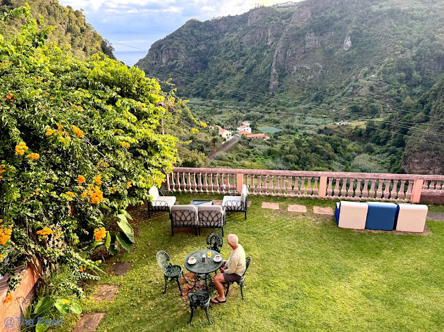
We started our morning with breakfast in the yard of our Inn. The view, the service and the food was fantastic. It is so peaceful here. Today we drove west along the north side of Madeira. Our first stop of the day was at the lighthouse in São Jorge. It was very close to where we had dinner last night. From there we took in the sights wherever we could find a look out. The closer we got to the west end of the island the clearer the skies became. People have told us if we don’t like the weather where we are…just drive somewhere else in Madeira and you can find a little sunshine. It seems to be true. The clouds roll in and out very quickly.

It was a little chilly this morning. I took this picture when I came up to the room to get a jacket.
Ponta de São Jorge Lighthouse is an active lighthouse located on the north coast of the island of Madeira. The lighthouse was built in 1959. 
Looking down on part of São Jorge.
Views in Boaventura valley. No tunnels here. You drive up and around the valley. It was so pretty.
The town of Boaventura.
Chapel of Our Lady of Fatima in São Vicente is one of the most scenic churches in Europe. It was built in 1948 to celebrate the end of World War II. We climbed 200 and were rewarded with stunning views. 
Views from the Chapel of Our Lady of Fatima in São Vicente.
Just past São Vicente was this amazing waterfall called Cascata Água d’Alto. It drops from the mountain and runs under the road to the sea. It’s one of the highest on the island at 494′. Can you see the tunnel?
Less than two miles from the first waterfall we stopped at there was a lookout that was the perfect spot to see the coastline and the Córrego da Furna Waterfall. It has a drop of 192′
From the same overlook we could see the little beach town of Seixal. It has Madeira’s only black sand beach and several natural pools.
Seixal Black sand beach…can you see the waterfall. Madeira only has a few sand beaches. Most are rocky and not good for swimming.
We stopped at a little café for lunch that overlooked the natural public swimming pool. We only had a few ponchas and bolo do coca (wonderful garlic bread). I put my feet in the pool and it felt nice.
After lunch we headed further west. By now the day was beautiful.
We took a small local road instead of the tunnel and found this beautiful spot and another waterfall. 
Our next stop was at Ilheus da Ribeira da Janela. This is one of the most iconic viewpoints on the island, looking onto several uniquely shaped rocks that protrude from the ocean floor. There were hundreds of cairns along the beach. I don’t know how they got some of them to balance.
From Ribeira da Janela we could see our next stop…Porto Moniz.

These are just a few of the natural pools in Porto Moniz. I will have more about these pools in the next post. On the high in the background is Ilhéu Mole Lighthouse.
Our last stop of the day was on the far west side at Achadas da Cruz Cable Car. The car that took us to one of the most unique spots in Madeira, Fajã da Quebrada Nova. It’s a tiny place on the northwestern coast of the island that is isolated from the rest of the world by the tall mountain cliffs on one side and the ocean on the other. The cable car serves tourists and local farmers. In fact a cable car was installed to help the farmers transport their harvests.

This cable car goes down almost 1,500′ at a 98% slope. It’s the Europe’s Steepest Cable Car

This was by far the hottest place we went on the island. Very dry and very warm. It was interesting but we definitely wouldn’t wait in line to do this again. By the time we got to the bottom we didn’t have a lot of time to look around before we had to get in line to come back up.

We read while doing research that you could actually spend the night in the little village at the bottom. You have to bring everything with you.

Port Townsend to Bainbridge Island (via San Juan Islands)

2023-04-006xGetting hauled out and having your boat worked on is always stressful. Since we have no land-based living accommodations in the area, we continue to “live” on the boat while it sits on stands in the boatyard. That means we can’t spill any water overboard, black (most certainly!) or even grey. We do have holding tanks for both kinds, but they are not so large that they can be used for much more than a week of “normal” use. Consequently, we try to put nothing in the holding tanks. That means no cooking beyond boiling water and using on shore toilet & shower facilities.

2024-Cruise-202xBoatyards are usually dusty because of the sanding and grinding, either on your boat or other boats in the yard. There can be lots of foot traffic from the coming and going of the workers doing the work. Each new foot brings a little more dust on board.

On our work list for the folks at the Port Townsend Shipwrights Coop (PTSC) were routine maintenance items (e.g., bottom paint, new sacrificial anodes), repairing failed/failing items (e.g., the anchor windlass), and upgrading components. We spent 11 days out of the water, being hauled out on Monday, 8/19 and launching on Thursday, 8/29. We spent the night after launching in Port Townsend before departing on Friday, 8/30.

The last several years we have spent 1 – 2 weeks at the end of our cruising season in the San Juans. While it is still crowded compared to SE Alaska, September, after Labor Day, isn’t quite as crowded as in July and August. Setting realistic expectations is the key. If you expect to share the anchorage with 40 other boats, you shouldn’t be upset if it turns to be true. And if there are only 35 boats, you’re ahead of the game.

2018-Cruise-391xThe nice thing about San Juan Islands is how compact they are. Twenty-five miles is probably the furthest you’d have to travel to get from any two anchorages on any of the islands. With good shore access at the many parks, it encourages a slow pace. As a result, Drake gets frequent walks and ball play when we visit. This year we stopped at Reid Harbor (Stuart Island), Garrison Bay (San Juan Islalnd), Griffin Bay (San Juan Island), Deer Harbor (Orcas Island), Fisherman’s Bay (Lopez Island) and, Echo Bay (Sucia Island). We used Hunter Bay (Lopez Island) as our last stop before crossing the Strait of Juan de Fuca and slogging down Admiralty Inlet on the way to our home port in Eagle Harbor on Bainbridge Island.

We arrived Eagle Harbor in the early afternoon on Sunday, September 15. In total, we were gone 135 days but I am going to attribute13 days as time in the boatyard and not count them. Of the 121 nights out on the cruise, 73 were at anchor while 48 days were on docks. We put on 3,091 miles in 503 cruising hours (we had an additional 27 engine hours trolling or idling while fishing (mostly deploying or retrieving prawn pots).

Guam to Chile – Blog Post 6

September 14, 15 2024 At Sea between Pohnpei and Bakawari, Papua New Guinea

Departing Pohnpei about 1930, Seabourn Pursuit continued south overnight.  The wind and swell were on the beam, with the seas about 10 feet at 9 second period, so the ship had moderate roll motions.  This wave height is typical for the Pacific Ocean, which has an average wave height of 3 meters.

The sunrise was spectacular once again and we had no rain all day.  At 1400 we held the Equator crossing ceremony and my sister, Julie, being a Polliwog, was inducted during the ceremony into being a Shellback, so we now had permission from King Neptune to cross the equator with no Polliwogs on board.

Lectures today included one on Seabirds and another on mangrove swamps.

September 15, 2024 – At Sea

September 16, 2024

The Seabourn Pursuit took up position off Bakawari Island, Papua New Guinea at 0600.  

Bakawari Island lies next to Bougainville Island
Papau New Guinea

The ship was cleared by the local authorities about 0700 and Patrick headed off for a Kayak excursion.  At 0830, other guests were shuttled ashore in color groups and were treated to a folkloric performance by three local groups on Bakawari Island.  The kayak tour finished just in time to be delivered to the beach for the performance.


Dancing at Bakawari Island

Some of the bamboo flutes used by the performers
Native canoes fishing

Coral formation while kayaking

Native Canoe


By 1200, all guests were back on board and Seabourn Pursuit headed for Honiara, Guadalcanal, Solomon Islands, our next destination.  Our route takes the ship down the “Slot”, through Bougainville Straits and past Savo Island before docking at Honiara.

The area we are transiting is larger than we expected.  The distance from Bakawari Island to Honiara, Guadalcanal is 335 NM.  To make that distance overnight means Seabourn Pursuit has to average more than 15 knots.  Fortunately the seas and wind are favorable.

One of the reasons for making this cruise is the opportunity to visit locations in which my father served while in the USN in WWII. 

This morning, with calm seas and sunny skies, we are approaching Savo Island and will pass by the final resting place of the USS Astoria, which sank following a fierce night battle just off Savo Island, only two days after the USMC landed at Red Beach on Guadalcanal.  The night of August 9, 1942, a night attack by the Japanese navy caught the allies off guard.  Four heavy cruisers were sunk, three US and one Australian.  Three cruisers were sunk in just a few minutes between 0230 and 0300.  The USS Astoria did not sink immediately, but was badly damaged.  The crew initially abandoned ship, but later 350 crew returned to try and save the ship.  My father was one of those who returned to the ship.  He told us about jumping off the bow initially, and returning to collect the bodies of those killed and preparing them for burial by sewing the corpses into hammocks while eating stewed tomatoes since the galleys were unusable and on fire.  Initially we were skeptical of some aspects of that story, but when we saw the same story in other eyewitness accounts, we were convinced he had survived a horrific experience.

However, the crews’ efforts were in vain, as underwater explosions in the bow area fatally damaged USS Astoria (my father was aft at that time).  The ship was abandoned once again and at 1215 that day, August 9, 1942 the USS Astoria listed 30 degrees, then capsized and sank stern first in 2800 feet of water about 2 miles from Savo Island.  More than 247 sailors perished and another 250 were wounded.  It was the worst defeat at sea for the US Navy, excluding Pearl Harbor.  The USS Astoria was rediscovered by Paul Allen in 2015, in 2800 feet of water, with the bow missing.

The bridge display as we were at closest point to Astoria

Last known phot of Astoria, one day before sinking

Photo of Astoria remains by Paul Allen

Savo Island


We wer fortunate to be on the bridge of Seabourn Pursuit when we passed just 2.85 nm from the location of the USS Astoria.  We observed several minutes of silence in memory of the hundreds of navy personnel who died in that action on both the Astoria and the other three ships.

My father was then reassigned to the destroyer USS Blue.  That ship was torpedoed on August 22, 1942 and scuttled on August 23, 1942, after unsuccessful attempts to save her.  My father also survived that sinking.

USS Blue – DD-387


The area between Savo Island and Guadalcanal has been named Iron Bottom Sound, since more than 50 allied and Japanese ships were sunk in the 7 month Guadalcanal campaign.  Iron Bottom Sound is considered a sacred place due to all the people who perished and whose remains went to the bottom.  Guadalcanal and the Solomon Islands campaigns marked the beginning of the successful, but bloody island hopping strategy which the Allies used to eventually defeat Japan.

The Battle of Savo Island was also a turning point for the US and it’s allies in that the Japanese failed to destroy the troop transports and supply ships lying off of Red Beach, just a few miles from the Savo Island battle, instead withdrawing after destroying the four heavy cruisers.  The pattern of tactical victory but strategic mistake would persist throughout the war.

Seabourn Pursuit docked at the container port in Honiara, Guadalcanal at 1100, and by 1140 we were on a bus tour of the Eastern Battlefields of the Guadalcanal campaign.  

Honiara is the capital of the Solomon Islands, a sprawling independent nation with more than 95 major islands and a total population of more than 700,000.  Honiara has a population of about 65,000.  This island nation is being impacted by climate change, with sea levels rising 8 mm per year, more than the average worldwide. The evidence of WWII is still present, with significant amounts of unexploded munitions still being discovered 82 years later.

The first tour stop was at Red Beach, where the USMC landed on August 7, 1942, with little opposition.  That was soon to change as the USMC took control of Henderson field (our second stop) and set up defensive perimeters, including one at “Bloody Ridge”, our third stop of the tour.  We finished the tour with visits to the Japanese War Memorial and the the US War Memorial.  The Guadalcanal took seven months to achieve victory, with more than 7,000 Allied deaths and more than 19,000 Japanese deaths.


Monument at Red Beach

Red Beach

Memorial Park at Henderson Field

View from Bloody Ridge

Monument at Bloody Ridge

Japanese War Memorial

View of Savo Island from US Memorial

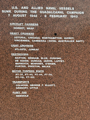
Battle of Savo Island at Memorial


List of US Ships sunk at Guadalcanal


At 1800, Seabourn Pursuit cast off the lines and continued the journey in Melanesia.  Our next port of call is Luganville, Espiritu Santo.