Archive | Moor $tuff RSS feed for this section

Moor $tuff 2012-08-11 11:58:00

Friday, August 10, 2012

82°31.457’ W

43°16.167’ N

Lexington State Dock

Lexington, Michigan

HAPPY BIRTHDAY MARK!

The bad weather continues to keep us in port. It’s looking like we’ll be here through Sunday or
Monday.

With all of this extra time on our hands we did put on our rain gear and walk into town to get our hair cut! Barb took the time to do laundry and I did a few projects in the engine room! Not to exciting but productive!

Barb and I have learned that the weather service does make mistakes from time to time so will be up early looking for a break in the weather and a chance to move up the coast.

Moor $tuff 2012-08-09 14:44:00

Thursday, August 9, 2012

82°31.457’ W

43°16.167’ N

Lexington State Dock

Lexington, Michigan

Our good luck with the weather has run out! Small craft warnings with possible gale force winds have been forecast. Wave height predictions could see 15 footers. What this means to us is we will weather out the inclement weather lashed to a dock in Lexington, Michigan!

My best guess is we will be here three or four days before the bad weather breaks and lets us move north.

Moor $tuff 2012-08-09 14:44:00

Wednesday, August 8, 2012

82°31.457’ W

43°16.167’ N

Lexington State Dock

Lexington, Michigan


View from our slip at
 Belle Maer Harbor


Leaving Belle Maer Harbor


Our goal today was to reach the port of Port Huron. The weather was clear and wave height was reasonable. Our problem today was, we were slowed by the 6 mph current until entering Lake Huron. Once in the wide open lake our speed returned and we pushed on for an additional 20 miles.


Ferries crossing


Ship’s we waited for


On the way we saw fuel for $4.06 a gallon and thought it a mistake but it wasn’t so stopped and topped off. We were told that as soon as the fuel truck arrived the price would be raised to what ever he had to pay plus markup.


When we entered the main river we were met by two ships that crossed directly in front of us. Considering how big they were I laid back and watched them pass in review.

Industry along St. Clair River


Boat house


We made another 65 miles today and wonder when the weather will turn on us. The weather predictions are not good for the rest of the week so ——- stay tuned!


Homes along St. Clair River
Entrance into Port Huron

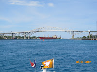
Blue Water bridge connecting
USA and Canada

Lake Huron

Entering Lexington State Harbor

Barb and I took time to walk into the town and enjoy a pizza. What we saw was an all American small town that was fun to visit.

Moor $tuff 2012-08-09 14:44:00

Thursday, August 9, 2012

82°31.457’ W

43°16.167’ N

Lexington State Dock

Lexington, Michigan

Our good luck with the weather has run out! Small craft warnings with possible gale force winds have been forecast. Wave height predictions could see 15 footers. What this means to us is we will weather out the inclement weather lashed to a dock in Lexington, Michigan!

My best guess is we will be here three or four days before the bad weather breaks and lets us move north.

Moor $tuff 2012-08-09 14:44:00

Wednesday, August 8, 2012

82°31.457’ W

43°16.167’ N

Lexington State Dock

Lexington, Michigan


View from our slip at
 Belle Maer Harbor


Leaving Belle Maer Harbor


Our goal today was to reach the port of Port Huron. The weather was clear and wave height was reasonable. Our problem today was, we were slowed by the 6 mph current until entering Lake Huron. Once in the wide open lake our speed returned and we pushed on for an additional 20 miles.


Ferries crossing


Ship’s we waited for


On the way we saw fuel for $4.06 a gallon and thought it a mistake but it wasn’t so stopped and topped off. We were told that as soon as the fuel truck arrived the price would be raised to what ever he had to pay plus markup.


When we entered the main river we were met by two ships that crossed directly in front of us. Considering how big they were I laid back and watched them pass in review.

Industry along St. Clair River


Boat house


We made another 65 miles today and wonder when the weather will turn on us. The weather predictions are not good for the rest of the week so ——- stay tuned!


Homes along St. Clair River

Entrance into Port Huron

Blue Water bridge connecting
USA and Canada

Lake Huron

Entering Lexington State Harbor

Barb and I took time to walk into the town and enjoy a pizza. What we saw was an all American small town that was fun to visit.

Moor $tuff 2012-08-08 20:10:00

Tuesday, August 7, 2012

82°47.716’ W

42°36.304’ N

Bell Maer Harbor

Mt. Clemens, Michigan


Leaving Gregory Boat Co.


Homes along the way


Today was a short day on the water. After cruising 27 miles we entered a huge harbor filled with 940 boats. Every slip had parking in front of the boat slip with ample grass and trees to make for a park like setting.

We called Heather and Larry and were able to schedule a visit to their home. Heather came to the boat and drove us to their home for a very special dinner. Their home was beautiful and the food was great! They drove us back so Larry could see the boat and gave me a few pointers on how to cross the shallow lake and safely pick up the north canal that takes you into the St. Clair River.


Canadian Coast Guard


Arriving in Mt. Clemens


Tomorrow we will experience currents as high as 6 mph on the nose —- that will slow our progress down!

Moor $tuff 2012-08-08 19:52:00

Monday, August 6, 2012

82°58.778’ W

42°21.273’ N

Gregory Boat Co.

Detroit, Michigan


Leaving N-E Port Marina


Barb and I delayed our start trying to figure out the weather on Lake Erie! Once we decided it was a go we moved our boat to the fuel dock to experience a gas price hike of .54 cents a gallon since entering port three days before! I’m not sure what’s going on but the gas industry isn’t being very kind! So much for complaining —- I paid the bill and off we went.


Detroit Light


Detoirt Skyline


Downtown Detroit


The lake wasn’t as bad as predicted and we had a bumpy but pleasant trip to the entrance of the Detroit River. Along the way and at the entrance we experienced ship traffic one being a 1000 foot ore carrier. When you stack our 35 foot boat against a 1000 foot ore carrier there isn’t any thing to compare. We followed on old Laker into the river and slowly lost sight of it as it proceeded up the river. As we progressed north the current began to increase slowing our boat over 2 mph.  I was told as we progress north the current will get stronger until reaching Lake Huron.


We didn’t have a destination planned and randomly selected Gregory Boat Co. that had good prices, a great ship store and very good security in the middle of Detroit. As soon as we had the boat secured I changed the oil in both engines before calling it a long day.

Tomorrow will be a shorter day as we will cruise into Lake St. Clair and visit Heather and Larry, friends we met while in Mexico.